Directions to South Fayette High School
|
If you are using a GPS to find our high school, our address is:
3640 Old Oakdale Road McDonald, PA 15057 Please note, when you arrive, the High School is at the rear of the campus. All buses should pull to the rear of the high school for unloading. Buses will park after student drop-off in the Stadium Parking lot. |
From Interstate 79
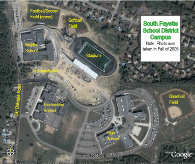
Take South Fayette/Upper St. Clair exit (Exit #54), turn left off exit onto Route 50 West. Take first exit to the right, which is Millers Run Road. Travel on this road approximately 2½ miles, then turn right at “VFW” sign onto Old Oakdale Road. Travel on this road approximately 2 miles (be advised that this road is a very windy road and you should watch your speed). Schools are on the right (Elementary school is the first large building; high school sits behind elementary school; middle school is the next large building past the elementary school.
Parkway West (From Pittsburgh)
Take the Parkway (towards the new airport). Then take the Washington, PA exit towards I-79 South. Continue on I-79 South and then take the South Fayette/Upper St. Clair exit (Exit #54). At the end of the ramp, turn left onto Route 50 West. Take the first exit to the right, which is Millers Run Road. Travel on this road approximately 2½ miles, then turn right at the “VFW” sign onto Old Oakdale Road. Travel on this road approximately 2 miles (be advised that this road is a very windy road and you should watch your speed). Schools are on the right (elementary school is the first large building; high school sits behind elementary school, and the middle school is the next large building past the elementary school).
Parkway West (From Airport)
Take Route 22-30 exit heading towards Star Lake (Post Gazette Pavilion). Take the Oakdale exit. Turn left off the exit at the traffic light and follow the Orange Belt into Oakdale (approximately 2-3 miles). Merge straight in Oakdale and turn right at Thomas Little Funeral Home onto Union Avenue Ext. (continue on Orange Belt). Proceed for 1 mile to the top of hill and then turn left onto Battleridge Road. Travel approximately ½ miles and turn right onto Old Oakdale Road. First large building is the middle school; the next large building is the elementary school with the high school sitting behind the elementary school.
Via Route 60 (Steubenville Pike)
You may exit 79 South at the Route 60 – Airport Exit until you pass Robinson Towne Center (on right) and cross over the Parkway. Then follow the above directions from Parkway West (from Airport).
Via I-79 South & North (Via Chartiers Valley High School)
Take I-79 South and/or North to the Kirwan Heights exit. At the red light go left onto Washington Pike. At the next red light hang a left onto Thoms Run Road. You will stay on Thoms Run Road (passing Chartiers Valley High School on the left, Chartiers Valley Primary School and bus garage on the right, Demsher Beer Distributor on the right and the Presto Post Office and Fire Station on left). As you pass the post office and fire station, the road splits into a “V”. Bear to the right which is still Thoms Run Road and/or the Orange Belt. Continue on this road for about 2-3 miles (be aware that once you go past the “S” turn on Thoms Run Road the road will become Battle Ridge Road, stay on Battle Ridge Road). When you come to the top of the hill, approximately ½ you will see a flashing school light, there you will make a left turn onto Old Oakdale Road. As soon as you pass the housing plan, South Fayette Middle School will be the first building and the football field sits behind this school; next is the Administration building, and the next large building is the elementary school. The high school sits directly behind the elementary school.
From the Turnpike
Take PA Turnpike to Monroeville Exit. Proceed towards Pittsburgh (376 West) to Interstate 279 South. Follow I-79 directions to South Fayette Schools.
